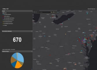
A map that helps U.S. officials track opioid overdose spikes originated in Baltimore.
ODMap presents a visualization of real-time overdose data across the country, Wired reports. It was created after officials at the federal Washington/Baltimore High Intensity Drug Trafficking Area wanted a way to present up-to-date information for police, public health officials and first responders. They used “street-level data-tracking tools” from Esri to create it., Wired reports.
The map helps the officials draw correlations between overdose spikes. One such example happened between Anne Arundel County and Berkeley County, West Virginia. Officials saw a “ripple effect” between the two communities as overdoses spread. The data also helped police draw a link between drugs traveling between the two regions.
READ FULL ARTICLE HERE